Bill Rankin’s 2013 Map of “The Midwest”

A colleague recently tipped me to a Bloomberg Media article about radical cartography, focusing on an interview with Bill Rankin. Before I moved to Michigan from Tennessee, I would never have considered that some people and agencies would consider the latter to be a part of the Midwest. According to Rankin’s aggregate map (below), the region stretches from Ohio to the Rockies, though I don’t know if people who live in the Plains region universally consider their states as “Midwestern.”

In my mind’s eye, I consider Pittsburgh to be the Eastern gate into the Midwest region from Appalachia, which separates the East and Mid-Atlantic from the Midwest and South. Of course, having lived in Syracuse for several years, I consider Western New York to be part of the Midwest, too, and it barely even registers on Rankin’s rendering.

Huh.

Sh__ from an Old Notebook: Naketa Beach Walk (Mukilteo, WA)

In preparation for AAG next week, I’ve been combing through some old notes from old conferences in Evernote (which technically still counts as a notebook), and I found this gem of a note from July, 2013:

6026 88th St SW, Mukilteo, WA 98275
http://goo.gl/maps/VyidT

The train just passed between this area and a row of houses on the beach that had no apparent way to access them. Look up in greater detail on Earth when you can.
See, I was on the Amtrak Cascades line north of Seattle en route to Vancouver, and I did a double-take as the train zipped by this weird outpost of houses lined up on the beach that seemed to be separated from any discernible roadway by the train tracks. I quickly took my coordinates (or something close to them) and pasted them into a note, and I guess “when you can” became “in almost four years.” Either way, I just looked up those coordinates on Google Earth, and I found that little row of houses by the Puget Sound. The addresses are in the 8000 block of something called Naketa Beach Walk.

Go ahead and zoom in. I would imagine that it wouldn’t be called a “Walk” if cars were allowed on it or close to it. But my big question is still how people gain access to those houses; is there a tunnel I’m not finding? The aerial imaging gets somewhat dicey the closer you zoom in and around the site, as the trees are digitally altered above the tracks. Also, the shadows over most of the track don’t help the investigation, either. It appears that the closest place anyone can park a car is on the other side of the tracks there, where Naketa Beach Walk meets Naketa Beach Rd and Naketo Branch.

I just found this video that a Youtube user named Justin Donnelson uploaded of a panorama he shot from the beach by those houses. It doesn’t shed much light on how someone gets to that beach, but my “tunnel” theory hasn’t been proven wrong… yet.

So, have any of you ever been to this town or to this site? I’m genuinely curious. The more I toggle around Mukilteo, WA on that embedded map, the cooler the town looks! Hey, Mukilteo, WA, are you looking to hire a Geographer? …. and don’t take my inability to sort Naketa Beach Walk using remote sensing as any reflection of my qualifications.

Also, for anyone interested in train travel, take a ride on the Cascades line from Portland to Vancouver; it makes all other trains in the US just look silly.

Help Map a Historically Black Cemetery in East Knoxville

oddfellows_14139

Attention people interested in GIS and small-scale mapping!

My good friend Maegan Dennison from the UT-Knoxville Anthropology Department is heading up a new service project that will spearhead field mapping, GIS, and web mapping for the Odd Fellows Cemetery in East Knoxville. The field work would take place in the Spring before the vegetation starts growing back so likely January – March 2017. I’ll be passing this announcement on to my students in GEOG 320, but I wanted to get the word out here in case anybody may be interested in learning more about, and contributing to, this historically black cemetery.

If you’re interested and/or looking for more information, you can email Maegan at mdenniso [at] vols [dot] utk [dot] edu.

Locals and Tourists (Geotagging)

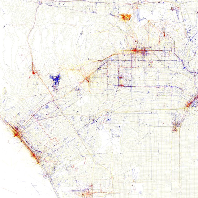
Locals and Tourists #15 (GTWA #47): Santa Monica and western Los Angeles//embedr.flickr.com/assets/client-code.js

While I am not as much of a cartography expert as I’d like to be, I wanted to share this project by the talented Eric Fischer. It landed on my news feed from Bill Bowen, the longtime chair of the Cal State Northridge Geography program and major benefactor of the Association of Pacific Coast Geographer (who you should hopefully have the chance to meet one day and chat with about the last six decades of Geographic education; he was there in Berkeley in the 1950s).

Anyway, Fischer’s project involves a heavy use of geotagging to cache where people discernible as “tourists” take photos in cities versus where those discernible as “locals” do. The results are not without the logistical issues (also, they are based on data from the beginning of this decade), but the visual output is stunning. It should also be highly intriguing and useful as a way to teach urban geography.

Locals and Tourists #4 (GTWA #3): Paris

Take, for example, the map of Paris above. Many of the red blotches are fairly easy to guess (The Eiffel Tower, Avenue des Champs-Élysées, and Notre Dame), but others make for a fun challenge (Père Lachaise Cemetery, Versailles, and ???).

Here, kids, is a tourist.

Here, kids, is a tourist.

I hope you’re all having pleasant Sundays and hope you enjoyed this.

Attempts at (Re)photography in Florida

A big thank you to all of the Geographers and supporters thereof who converged on the Tampa Convention Center and Marriott for AAG last week, and a big apology in advance to all the ones who I met that won’t hear from me for a little while as I’m busy catching up on work and otherwise getting my life back in order. I had grand ambitions to do some work while in Tampa, but if you’re reading this you can probably take a wild guess as to how that turned out. As anyone who’s been to a conference like it knows, everyone’s too busy being constantly distracted in order to really accomplish anything other than make new connections and pray they remember you.

That being said, I was excited to see the book with a chapter I contributed displayed prominently at the Ashgate table in the exhibitors’ hall in such good company.
130

I would love to give Tampa proper some attention here*, but in the interest of time, I’ll skip right to the point. A few months ago, I posted cryptically about some antique postcards that came into my possession. Where the postcards are from will hopefully one day be under an organized-enough umbrella to present here, but for now, let’s have a quick chat about (re)photography.

The term “rephotography” (alternate “re-photography” or “(re)photography”) didn’t originate in Jason Kalin’s 2013 article (found here), but he did bring the scope of its uses to my attention last year. Considering how easy the internet has made it, our culture can barely digest content without (re)contextualization. This is both a good and a bad thing, but acting on what I hope is a good manifestation of it, I decided to set out on foot from the Tampa Convention Center to try to recreate one of my the postcards myself. The over-friendly hotel concierge** told me the Davis Islands were located a walking distance from the downtown area, though strategically disconnected from the Convention Center area proper. I suppose they didn’t want legions of drunken Lightning fans stumbling over from the Forum into their bars (which are located way too deep into the island for the casual ambler).

Anyway, here is the result of my efforts:

DavidIslandsTampa_1938153

Not perfect, but I would have needed to defy death and stand in the middle of Bayshore Boulevard in order to get a more accurate recreation of the original artist’s perspective. Also, the bridge from Hyde Park over to Davis Islands has been remodeled, and the Davis Island residential areas of 2014 are a far cry from that of the pre-War era. Obviously, the hospital and adjacent office buildings were not there when D.P. Davis*** imagined this crazy project before building it and disappearing.

From what I can tell, the fencing by the harbor has largely retained its character, and the vegetation nearby in the foreground is even quite similar to the classic depiction. The bright yellow building depicted on the postcard can be seen at a distance to the right of the hospital today, which helps highlight how the postcard image (obviously painted to sell the city and the Davis development) is based on an off-scale interpretation. I would need to dig deeper and find archival photographs of Davis Islands in order to determine what exactly was misrepresented, and thanks largely to the conference that brought me to Tampa backing up my workload, I have no time right now. At least there’s always Google, right?


LINER NOTES (SPECIAL “IF” EDITION)

* If you’re in Tampa, though, and looking for great places to hang out, look no further than New World Brewery (Ybor City), The HUB (Downtown and if you’re okay with smoke), and the Independent (Seminole Heights, next to the wonderful money-pit Microgroove record shop). Full disclosure, we didn’t make it into the Independent since our ride downtown was leaving, but you could just tell it was awesome.

** If you’re wondering if that’s a reference, the answer is yes.

*** If you want to read one of the most fascinating accounts I’ve found about the mysterious Florida land developer, check out this history thesis by Rodney Kite-Powell. It helps explain his legacy and bizarre disappearance.

Geography vs. Geology

I have been traveling and sizing up the next place I’ll be living, studying, and doing research. More on that soon. For now, I’m hanging out in the Midwest for a few and sizing up a few different writing projects. More on those soon, too.

For now, edu-tain yourselves with this great little piece someone I knew from my program at CSULB helping solve an age-old facepalm-inducing confusion. Please forward to anybody who doesn’t know the difference in 2013:

Geography vs. Geology.

Storage Wars: CSULB Edition

Image

The one folded back into a book. Early settlement patterns of colonists in the United States, pre-1700.

My friend David and I decided to rummage through our department’s storage pit, unearthing a ridiculous bounty of USGS Maps from the post-War era that covered everything from climate to topography, as well as innumerable other classroom treasures from over forty years ago. It’s crazy just how much physical material passed through a typical Geography department before the digital revolution; I can understand why nobody was particularly sad to transition to zeros and ones. Still, we barely found anything that wouldn’t look awesome on someone’s wall. We’re currently thinking about doing a CSULB antique map show somewhere in Long Beach this spring.

Image

We found a beautiful hand-drawn map of Hungary on the back of a classroom map of Europe. If you had any hand in this, contact me so we can give credit.

Image