Postcards from Irving 7 OUT MONDAY

[in best Avon Barksdale voice] “Surpriiise!

Volume 7 of Postcards from Irving is out Monday 3/11.

The contents include
All Towns Small but Interesting: Port Huron, MI
Venue Stories: The Hawaiian Room at the Lexington Hotel, NYC
The Ben Irving Songbook: “Post Office Complaint”
Plus a bonus, spirited rant inspired by finally reading James Howard Kunstler’s The Geography of Nowhere (1994).

If you would like a copy, some copies for your distro, or would like to subscribe (The 2024 run – Volumes #7-10 for $12 shipped) please reach out via the Instagram page. You can also mail $4 of well-concealed cash to Box 1309, Mt. Pleasant, MI 48804 and receive Volume 7 in the mail with a personal note. Just don’t forget to include your mailing address.

Postcards from Irving 5 Out Now ||| Friends of the Cabildo Lecture LIVE Online Tonight

There’s a lot happening in Ben Irving HQ to report. Well, there are two things happening, but they’re both pretty exciting.

First, Issue 5 of Postcards from Irving (Summer 2023) is out now! They’re available for $3 PPD or equitable trades. Back-issues are also available for $3 (Issue 4) or $1 apiece (Issues 1-3). You’re welcome to send cash to PO Box 1309, Mt. Pleasant, MI or email me with questions about subscriptions/PayPal. Some back-issues (along with many other good-times zines) are available from Policymaker.

Second, I’ll be lifting my (highly translucent) veil of obscurity tonight to present, live via satellite, “A Postcard Tour of Pre-War New Orleans” for the Friends of the Cabildo, a French Quarter-based history non-profit. The lecture will begin at 6pm Central Time (7pm Eastern), and costs $10 for the general public. Admission link passes are available here.

A Postcard Mailed Home to Brooklyn, February 2, 1941.

Postcards from Irving: Hammond, IN

For various reasons, I haven’t really been keeping the Ben Irving Postcard Project cross-posted between here and the Instagram account. I will try to change that this morning, but regardless: Volume 4 is in the finishing stages, and there will be a big announcement about that soon, along with some supplemental visual material posted here.

In the meantime, for this Monday, we’re visiting Hammond, Indiana – a small community in the Eastern reaches of Chicagoland, spitting distance from the Illinois border.

Irving mailed this postcard of the Northern States Life Insurance Company on May 12, 1942, and these photo reconstructions were taken on November 16, 2022. Today, the building houses a Montessori school.

Photo by Sonic Geography. All rights reserved.

More details in a future print edition of Postcards from Irving. Happy Monday.

‘Postcards from Irving’ Volume 2 Out Today

After a slight delay, the second issue of Postcards from Irving is now ready for printing and headed this week to a mailbox near you (ideally yours).

The masthead and table of contents are above. Ignore that zip code typo; it should read 48804, which it will on the actual zines. This volume is introducing a new format: a proper booklet style that still fits snugly in letter-sized envelopes. I hope you enjoy it!

There are a few visual pieces that I may crack and wind up sharing digitally. I posted the Iron River postcard in question (as well as a repeat-photo I took there in August 2021) on the Instagram page, so I’ll post it here too for resolution’s sake.

Enjoy this free preview, and if you haven’t already subscribed or donated to the cause, DO SO RIGHT HERE.

Iron River, MI (1939 Postcard vs. August 7, 2021)

Ben Irving visits Marquette Michigan, August 1941

From what I can tell, Ben Irving took two road trips through Michigan’s Upper Peninsula: once in May of 1939, and once in August of 1941. In both cases, he drove through from Wisconsin and continued down to the Lower Peninsula, taking one of nine auto ferries across the Mackinac Strait (the Mighty Mac suspension bridge would not open until 1957).

He did not make it to Marquette, the largest town and cultural anchor of the U.P. (Joe Pera decided to set his TV show there, if there may be any doubts) until his second trip. Avoiding a stop in Marquette may seem odd today, but most towns up there that feel like hollowed-out blips on the map in 2021 were robust mining towns preceding World War II. After I visited the Keweenaw Peninsula, for example, it seemed blatantly obvious that mining is why Michigan Technological University is located way up there in Houghton. Also, the location isn’t really too far afield to other North-Country cities like Duluth and Green Bay; it just seems like a massive haul to any of the “trolls” (an endearing term for those folks who live in “under the Bridge” in Michigan’s lower peninsula, about 97% of the state’s population).

As various friends and colleagues had predicted, my partner and I thought Marquette was awesome. Northern cities, especially those as remote as Marquette, have a special charm to them. Locals tend to be good at making their own fun. Much of the city is contained within hills that bottle it on a descent into Lake Superior, where one finds the massive, lumbering ore dock situated down the street from a nice brewery that bears its name.

Downtown Marquette, MI (with the ore dock seen at left) taken from the penthouse of the Landmark Inn (SonicGeography.com).

The Landmark Inn (formerly The Hotel Northland)

Unlike other small Michigan cities, Marquette retained a majority of its beautiful early-20th century stone architecture, particularly along Front Street, leading up to the Landmark Inn, where Irving stayed in August 1941. At the time, it was barely over a decade old and called itself the Hotel Northland.

There are plenty of sources that claim the building is haunted, particularly the Lilac Room on the top floor, where a young librarian allegedly hanged herself in grief over her lover dying sailing on Lake Superior. There are also urban legends that tell of a jealous man who murdered his unfaithful girlfriend and buried her body in the hotel’s foundation sometime in the 1920s. In both cases, paranormal enthusiasts report hearing noises that suggest neither young woman ever truly left the hotel. Of course, the hotel’s spartan official history doesn’t mention any of this.

Though the Hotel Northland’s original era ended with its closure in 1982, the Landmark group refurbished the building in 1995. The results, as one might expect, are grandiose and expensive. Like most hotels who haven’t had a date with the wrecking ball, this one was fairly easy to re-photograph. I stood in front of the Peter White Public Library to get my photo, as the original photographer/painter did ninety years ago. Here is the result:


Harlow’s Wooden Man

My partner and I spent a good few minutes wandering around the corner of Spring Street and 5th Street, where I read in a few different, confusingly phrased accounts that Harlowe’s Wooden Man stands today. The landscape over which he towered 80+ years ago is almost completely overgrown today and encased in private property. At first, I felt the standard type of garden-variety indignity an Urban Geographer like myself would feel seeing any piece of bizarro history is fenced off from public enjoyment. Then, I realized that HWM probably owes his “life” to being neglected in some wealthy person’s back yard. Like countless others who walked down the fencing behind an Advance Auto Parts, I felt the temptation to jump the chain-link fence and get a cheeky selfie with the wooden giant. If he were on public property, the city of Marquette or some niche historical society would have to encase him in some type of panopticon to prevent a bunch of hooligans from climbing onto his withered old shoulders and toppling him into a pile of lumber.

The story behind this highly unusual (though I doubt unique) hidden attraction is unusual in itself. According to local lore, Amos Harlow (the postcard misspelled his name – probably an honest error by the publisher) was out for a walk in 1875 when he saw a cedar tree that resembled a person, so he decided to cut it down and bring it to a hill behind his home, where he added various embellishments, including a cane and fine hat. I don’t know if the cane and hat you see in the postcard image were Amos’ originals, but today the cane is long gone (a reflection of how uncool canes are now, for whatever reason), and his current hat resembles a cage of something that Uncle Sam might wear. Here are a couple of more detailed shots I could get from the other side of the fence nearby:

Today, the Marquette County History Museum names their quarterly journal after him, and it’s entirely possible that Amos Harlow’s descendants live in the house facing 4th Street on that property. It’s fun finding whichever photos of the wooden man taken over the years – the ones which have been digitized, anyway. One photographer who snapped an ironic image of HWM in the 70’s did so from behind the figure with permission from Harlow’s granddaughter, who he claimed lived in the house on the property. Notice, if you click on that link, that the wooden man didn’t have a cane in that picture, either. I would have to do a lot more investigative work to figure out when the old man lost it. Someone had better help him! He’s out in the middle of the woods (and on a hill!) without a cane!

It’s not perfect, but it’s the closest I could get to the original angle. ~1930’s (mailed in 1941) vs. 2021.

Thanks for reading, everyone. Have a great weekend.

A Postcard Mini-Assignment (GEO 121)

Here, I hold a stack of postcards written by my students in GEO 121 (Intro to Globalization), about to go into the post. As of this writing, they’re on their way all over the country.

I created this mini-assignment in equal parts as a tribute to the US Postal Service as well as a simple lesson on a lost art (or, at least a heavily niched one). So many students told me they had never composed or sent a postcard before. Well, now they have, and their friends and relatives are in for a surprise.

The Ben Irving Postcard Project: Belding, MI (1938)

In my half-decade of tracing Ben Irving’s path(s) through pre-War America through his postcards, I always look forward for opportunities to visit smaller towns left behind by post-War economic “progress.” Sometimes, that “progress” comes at a profound expense, usually as self-inflicted by local decision-makers as externally imposed by state and federal powers. Belding, a small city of roughly 5,000 in Ionia County, is a crystal-clear case study.

From what I can tell, Irving spent October 1938 in Michigan, bouncing around the lower peninsula while headquartered at the Detroiter Hotel. He spent much of the second week in the Southwestern corner of the Mitten, including stops in Benton Harbor, Muskegon, Ludington, Battle Creek (read about that here), and as one would imagine, the then-thriving metropolises of Grand Rapids and Kalamazoo. I’m actually well overdue for entries about his postcards from both Muskegon and Kalamazoo, but those will come in time.

Anyway, here is the original 1938 postcard image scan he mailed of downtown Belding (All Rights Reserved):

One of the first things I noticed driving into Belding was how sparse it felt. There were a few cool-looking blocks around the downtown area, and I saw plenty of cute neighborhoods on the periphery, but it just felt unspooled. I ate lunch at a café overlooking the river and went to get coffee and do some work at Third Wave Coffee, a great indie spot built into the street level of the 1913 Belding Brothers building at Main and Bridge. The owner and operator, Pete, told me a story (soon echoed by an equally helpful librarian) about an old woman who was struck and killed by a falling brick on Main St. sometime in the 1960’s. I found an article confirming that this happened in February 1966, as reported in the Petoskey News-Review (via UPI) on February 10th of that year:

Clipping from the Petoskey News-Review 2/10/66: KILLED BY BRICK. A Belding woman was killed and a 18-year-old girl critically injured Wednesday when a piece of decorative brick and mortar fell from a two-story building they were passing.

The article gave no other identifying information as to who the two women were, but it does confirm that the incident occurred on Wednesday February 9, 1966. The chances were fair that Belding’s powers-that-were had been looking for an excuse to move on some development contract. Stories like these were all too common in post-War, deindustrialized Michigan. As you can tell from the postcard (and if you’ve spent time in any Michigan city that was less aggressive with the wrecking ball), that crowning lip was a common adornment atop commercial buildings. They were too shallow to provide additional shade or shelter from the elements, but they did look nice.

Unfortunately, as these buildings crumbled, the slight jutting adornments became a severe liability. Detroit, for example, seriously cracked down on owners of derelict buildings that were raining bricks on passersby. Some of these owners decided it made more sense to just tear the buildings down than deal with other potential lawsuits and fines, especially since it felt like everyone they knew personally had vanished to the suburbs.

In Belding, the town’s elders decided that the best course of action was to just rip out the entire two blocks of Main Street depicted and turn it into a mall. Gaze upon its majesty.

Belding, MI. Main Street and Bridge, looking West.

I would bite my tongue if anybody I spoke to in Belding, given their half-century of hindsight, expressed any kind of enthusiasm for the mall. I’m sure that COVID had an influence on just how dead that whole area felt across the street, but it appeared that the Chemical Bank building on the right (on the site of what was once the Hotel Belding) had been vacant since well before the pandemic.

Keep in mind that my progress from that postcard image to the repeat-photo I took above was hardly a straight line. Pete identified Main Street, but because most of the pre-War buildings had been torn out before either of us were born, we had no visible reference points to confirm exactly where the photo was taken. I walked over to the Belding Library, named for, just like everything else Gilded-Age in that town, silk magnate Alvah Belding, who spent the last 56 years of his life in Connecticut until his death in late 1925.

I’ve written before how much I love librarians and how they’re some of the best public service workers in the world. The ones at the Belding library were case in point. I walked in and showed the postcard to one librarian behind the reference desk, and within two minutes, she reached into a nearby file cabinet and produced the following photograph, which we quickly realized was the reverse vantage point of the postcard image!

Image on the left property of SonicGeography.com / Image on the right property of the Belding Public Library.

As the caption on the sticker reads, “MAIN STREET LOOKING EAST,” and the postcard image was clearly taken around the same time period, and the orientation of the buildings helped me confirm that the picture was taken of the same block, looking West. She also produced what may be an original print of the earliest surviving photo of the Belding Hotel, possibly taken not too long after 1893, when the hotel was rebuilt following a fire.

Reproduced image courtesy of the Belding Library.

One detail to note is the Victorian-style house which stood to the right of the hotel on Bridge Street, also completed in 1893. Naturally, it was also flattened. As the chief history librarian (who returned from lunch and joined in our conversation) confirmed, the Belding Hotel once stood on the corner currently occupied by that Chemical Bank building, and nothing else but a grassy expanse and a sliver of the parking lot.

So, to review: If you’re ever in such a position to make the decision, don’t do to your downtown what Belding, MI did, kids. It doesn’t feel like it even paid off for them in the short run.

I genuinely hate WordPress’ new design interface, but this image-slide feature is changing my life.

A quick photographic lagniappe: the original chandelier from the Belding Hotel, now located and working within the foyer at the Belding Library at 302 E. Main Street.

Chandelier hanging in the Belding Library, Belding, MI (October 2020).

Thanks for reading, everybody. I hope your Octobers are going well so far, and are sufficiently spooky. Stay tuned for a bunch of inevitable “REDUX” posts of old Ben Irving Postcard Project images, now that I can overlay them with the slider.

Appearance on ‘The Postcardist’ Podcast for The Ben Irving Project

After spending almost two years trying to make it a reality, I finally got together (separately) with Frank Roche, host of the wonderful podcast The Postcardist to talk about my research, my family, Florida, and the Ben Irving Postcard Project. I’ll include a handful of links to listen to the episode below, but I have borrowed and posted the episode file here. Enjoy!

The Postcardist Ep. 84 08/23/20, Hosted by Frank Roche, guest Tyler Sonnichsen.

If you’ve never heard of this podcast, make sure to subscribe to it on Stitcher, TuneIn, Apple Podcasts, or whichever conduit you prefer!

The Ben Irving Postcard Project: West Tennessee

0331191842a_hdr

Lazy Sunday in Humboldt, TN, March 31, 2019. This and all images below belong to SonicGeography.com (All Rights Reserved).

Tennessee’s insane width (against its North-South length) presents a weird conundrum for anyone representing the state. Shortly after I moved to East Tennessee in 2013, a friend from Los Angeles surprised me with tickets to see FIDLAR at Exit/In in Nashville. I gave him a call on the long, winding, hour-losing ride home after the show to thank him, and he and I made vague plans should he ever come to Tennessee.

“If I ever get out there,” he said excitedly, “we’ve have to go to Graceland. I can’t miss that!”

I told him, in terms that wouldn’t put a huge damper on our conversation, that a trip to Graceland would require plastering at least three additional days onto his visit. For the amount of time we would spend in the car driving to Memphis (assuming some delays on I-40), drive to Tybee Island and jump in the Atlantic Ocean.

Largely for these reasons, my visit to Memphis for the wonderful Balancing the Mix conference at the end of March formulated my first trip to the Birthplace of Rock n’ Roll since 2011. For those doing the math, that was two years prior to my relocation to Knoxville. I’ve been a Tennessee resident for almost six years without one visit further West than Nashville. It’s disappointing, since I’ve met several visitors from Memphis, and I’ve been looking for a reason to get back out there. My 2011 visit, as brief as it was, clearly inspired me early in my geography career. One of the header images I use on this website is a photo of me standing outside of Sun Studios, after all.


Downtown Memphis (1935 / 2019)

Downtown Memphis, like I noted in my recent entry about re-tracing Ben Irving’s postcards in Nashville, reinforced a blanket notion about how increasingly privatized American cities have grown over the past few decades. Compared to when Ben mailed his postcards from Memphis (1935 and 1940), even the landmarks depicted have become surrounded by locked down landscapes.

MEMPHIS PARK

Before I made the (questionable) decision to check out Beale Street on that very cold and windy Saturday night, I stopped by Memphis Park, formerly Confederate Park, as seen in this postcard, mailed at midnight on March 16, 1935.

IrvingPostcard015

Obviously, the park is still there. I stood at the corner of Front St. and Jefferson Ave. and snapped this, the only shot anywhere close to recreating the postcard image.

0330192254a_hdr

Yeah, I’m fairly disappointed, too. The wind and cold were unbearable that night, which made even holding my phone-camera still enough to get the streetlights into focus nearly impossible. You can see the building in the background of both images. Today, it’s listed as the Cecil Humphreys School of Law (University of Memphis). In 1935, it was the Front Street Station US Post Office. The Court Square area was placed on the National Register of Historic Places in the early 1980’s.

In an attempt to subject myself to even more bitter winds at a slightly higher altitude, I looked around the intersection to see if I might get a superior angle. The first thing I noticed was a prominent parking garage opposite the intersection. Here’s a photo, which is actually ten times better than the above photo I took of the park. Figures.

0330192249a_hdr

‘Ooh!’ I thought. That upper level appears to be wide open, maybe I can just walk up the steps if it’s a public gara-NOPE, SORRY, TYLER, EVERY BLOCK OF EVERYTHING WITHIN 20 MILES OF ANY AMERICAN CITY’S CBD IS PRIVATIZED AND GUARDED 24/7 BY (probably underpaid) ON-SITE SECURITY CONTRACTORS. HERE’S A GATE IN YOUR FACE NOW PLEASE LEAVE WITHOUT A FUSS, SIR:

0330192252_hdr

I’m sure my reaction wouldn’t have been so visceral had it not been miserably cold, but I would not have been any less disappointed. I was grateful that the twenty-first century had at least dumped the ‘Confederate’ from the park’s name in 2013. You win some, you lose some. Moving onto the much sunnier and less windy Sunday afternoon…

HOTEL CHISCA

031635_Memphis_front

Thankfully, this one was a cinch.

0331191334b_hdr

Hotel Chisca, considering how MLK’s assassination occurred a few blocks down the street, had been in a decades-long decline before it was restored earlier this decade into the modern apartments that opened in 2015. The building itself first opened in 1913 and was in full operation as such when Ben mailed this postcard on March 16,  1935. Historic Memphis has a good overview (with a great catalog of artifacts preserved) on their website, including this tidbit about the hotel’s role, like so many places around the city, in Rock n’ Roll history.

The hotel’s historic significance comes mainly from its connection to Elvis Presley.  From 1949-56, its mezzanine was the broadcast base for WHBQ radio’s “Red, Hot, and Blue” program.  It was from there that Dewey Phillips broadcast Elvis’ first record July 7, 1954.  And Elvis’ first radio interview was also conducted in the hotel by Phillips.  

While the streetcar lines seem to function mostly to carry tourists up and down Main Street, I was glad to see they were in operation, unlike the Desire line, which had been long since ripped out of Royal Street in New Orleans. Here are some pictures I took of the current iteration of the Chisca building on different sides.

I’ve said this before, and I’ll say it again. Well, Sage Francis said it a while back, but I’ll borrow it from him in light of my experiences recreating these images of urban spaces in the United States: “the only thing that stays the same is change.”


Downtown Humboldt (1935/2019)

031435_Humboldt_front

One of the more obscure locations from which Ben sent a postcard was Humboldt, Tennessee, a small down located on State Road 79, about 20 miles North of where I-40 runs today. As is my bad habit when leaving anywhere, I pushed the beginning of my (very long) drive home well beyond the time I originally planned. I’d say it was well worth it after finding an old, dusty copy of Booker T. and the MG’s’ Green Onions (Stereo press from 1968, not the original 1962 Mono… I’m not a millionaire). Still, the sun was quickly caving into the horizon on my back when I rolled into downtown Humboldt.

0331191840a_hdr

From what I understand (and according to the Humboldt Historical Society), the town was on the L&N Railroad line. I think that Ben drove on most of his Depression journeys, but the railway still influenced his decision to pass through. I can only imagine how much Humboldt suffered following the demise of that line.

Since 1935, at least Main Street installed signal lights to handle the “onslaught” of traffic, and street parking had been sectioned off. Some of the buildings depicted in the gray-scale black and white postcard had also been knocked down and replaced. I walked up and down E. Main Street trying to figure out where, exactly, this original image had been taken. Thankfully, Sunday afternoon was relatively slow so I could stand in the middle of the street and not get run down. I made it all the way to the point where you can see those trees on the horizon of the postcard, where I found a small, public green space at the corner of Central Ave.

0331191843a_hdr

The Humboldt Plaza 3 cinema didn’t appear to be doing heavy business, but it was open and people were wandering in and out of it. According to the best website on the internet Cinema Treasures, the theater opened with 800 seats in 1942, seven years after Ben passed through and mailed the postcard. It was triplex’d in the early 1980’s, I imagine because it was the eighties.

I thought it would be fairly straightforward since the postcard clearly indicated the street and vantage orientation. I had gotten a bit too far ahead of myself. After walking up and down both sides of the street, trying to match a scratchy black and white image from the 1930s with the small town’s current formation, I finally found my architectural Rosetta Stone:

0331191849_hdr

The building on the NW corner of Main and S. 13th Avenue still has its gorgeous sculpted awning, albeit in two different colors. The left side was painted black to foil the whitewashing, as was the ornamentation over the windows. Whomever duplexed and renovated this building really had to commit; just look at the window decoration in the middle. To one person, it may be tacky, but to me… well, it’s tacky, but I love it. They bricked over the middle window with, it appears, slightly different, newer bricks. I can’t stop looking at it. It’s so distracting.

So, here was my conclusion. I took the first photo at an angle from the south side of the street, and I took the second about ten yards too far back, but you get the idea:

0331191850_hdr

0331191836_hdr

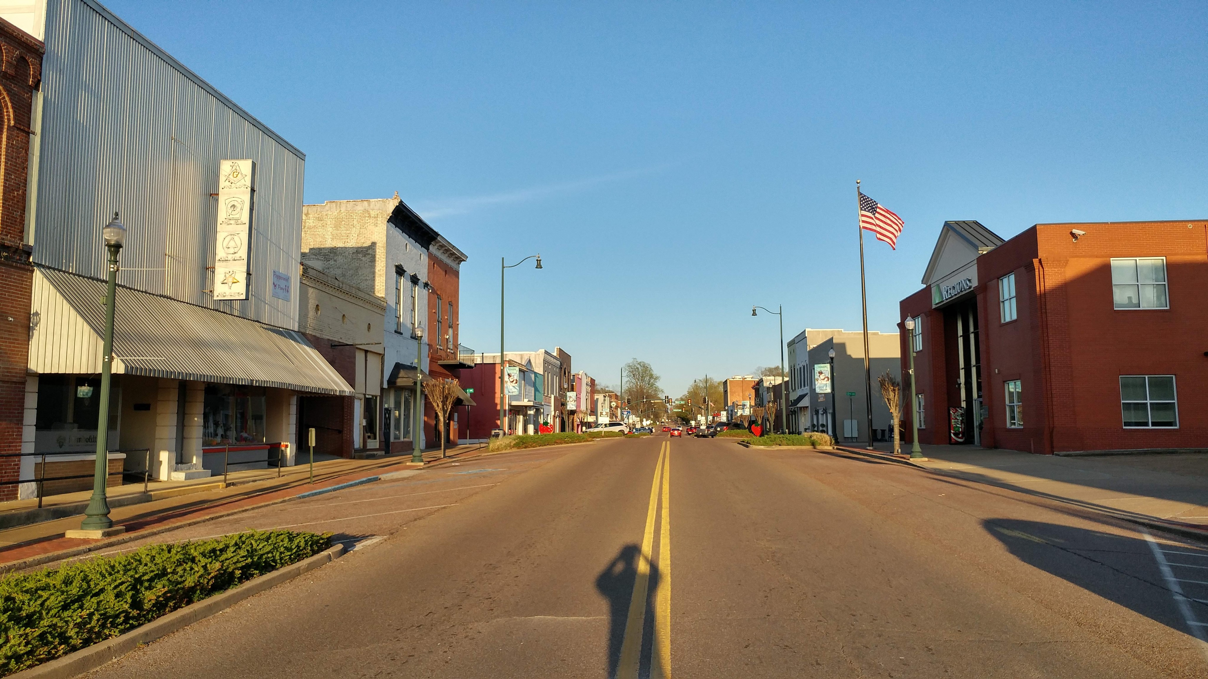
From what I can tell, the entire block opposite of the duplex building was torn down, eventually filled (sort of) with a newer Regions bank building. For a Sunday evening, there were a good handful of people wandering in and out of the Mexican restaurant and the movie theater. Strawberries featured prominently in the downtown corridor to signify the town’s annual Strawberry Festival, which appears to be Humboldt’s biggest tourist draw. I’m glad Ben Irving’s postcard drew me through here, the place seems to be a quintessential slice of West Tennessee that disappears under Memphis’ increasing weight.

0331191846_hdr


Alright – thanks to you (reader) for following this long long-term project on Sonic Geography, and thanks to the Ben Irving Postcard Collection for continuously providing a worthwhile distraction. Back to grading finals. Here are a couple more photos I took that don’t necessarily connect directly to the postcard sites, but I still love:

The Irving Postcards: Louisville, KY

1218181438_HDR

The United States Post Office, Court House, and Custom House in Louisville, KY (1936 Postcard Image, and December 2018). 

Last month, I spent a few days passing through the lower Midwest, including one of my favorite cities, Louisville. Not only is Louisville an overwhelmingly cool city with a great musical history (and according to Ethan Buckler a consistent threat of twisters), it’s also rich with history. Like its counterpart up the Ohio River Cincinnati, I imagine Louisville was a major crossroads during the antebellum era and reconstruction. It also gave us Muhammad Ali, quality baseball bats, and Elliott.

The two postcards I had on hand, like many items in the Ben Irving collection, were of newer landmarks the city was trying to show off in the WPA era. The Post Office and Memorial Auditorium both foreground Greco-Roman elements in their architecture. Only the Post Office postcard had any information about the building; it reads “Cost $3,000,000.00. Covers block on Broadway between 6th and 7th Streets.” Pretty straightforward. According to one inflation calculator, 3 Million dollars in 1930 would convert to $44,848,829.59 in today’s currency.

The more interesting building, for me, was the Memorial Auditorium. This postcard had absolutely no information on it, but according to the Auditorium’s official history, it opened in 1929 and was designed as a deliberate Greek Revival throwback by Thomas Hastings.

1218181417a_HDR

Louisville Memorial Auditorium (1936 Postcard / December 2018 in Background)

Though it looked like there were some city offices inside the building (I saw a security guard wander out one of the side doors and leave shortly after I took the above picture), nobody appeared to be home, so I couldn’t go inside. I did wander around the building to get a more detailed look. My favorite part may be the bas reliefs, which you can see pretty clearly on the 1936 postcard image.

Thank you for reading. Coming soon: a failed attempt at an ambitious vista re-creation in West Virginia!